Watersheds
Crawford County Interactive Watershed Map
Shenango River Watershed | French Creek Watershed | Oil Creek Watershed | Lake Erie Watershed
Shenango River Watershed
 The Shenango River Watershed originates in a large wetland area in Conneaut Township, Crawford County, and flows in a southerly direction from Pymatuning Lake approximately 70 miles to a point just south of New Castle in Lawrence County. There it joins the Mahoning River to form the Beaver River, which, in turn, empties in the Ohio River. Tributaries in Crawford County include Paden Creek, Linesville Creek, and Crooked Creek.
Interestingly, “Pymatuning” is taken from the Iroquois language and literally means, “the crooked-mouthed man’s dwelling place.” All together, the Shenango Watershed is comprised of 781 square miles with a human population therein of 167, 330 (2000). The DEP projects the population to reach around 180,000 by the year 2040, like it was in the 1960’s.
The Crawford County area of the Shenango comprises 120,700 acres, or about 188 square miles. It includes a major impoundment, Pymatuning Lake, which is operated by the Pennsylvania Department of Conservation of Natural Resources (DCNR) Bureau of State Parks. Pymatuning Lake is the largest man-made Reservoir in Pennsylvania, totaling about 17,000 acres of water. Pymatuning State Park provides extensive opportunities for swimming, fishing, boating, hunting, camping, biking and hiking. The northwestern section of the lake, Sanctuary Lake, is set aside for fish and waterfowl propagation. A fish culture station operated by the Pennsylvania Fish and Boat Commission and a wildlife refuge area operated by the Pennsylvania Game Commission are located around Sanctuary Lake. The lake yields an abundance of crappie, bluegills, bass, walleye, panfish and muskellunge. The lands around Pymatuning provide abundant habitat for geese and ducks. These animals depend on undisturbed land for nesting and need good water quality.
Pymatuning Lake drains into the Shenango system from two outlets. The first is Crooked Creek, which flows southward through the Pymatuning Marsh and through the Pennsylvania Game Commission’s State Game Lands #214. The gamelands area extends on either side of Crooked Creek almost to Adamsville. Over 30 species of mammals and 60 species of birds are year-round residents of the watershed. After emerging from the gamelands, Crooked Creek continues southward, marking the borders of East and West Fallowfield Townships. It leaves the county and in Stoneboro, Mercer County, joins the little Shenango River.
The second outlet to Pymatuning is the Shenango River, which flows southward out of the western lobe of the lake between South and West Shenango Townships. It is joined by the Little Shenango at Greenville in Mercer County.
Two other notable features within the Crawford County portion of the Shenango River Watershed are Crystal Lake (sometimes called Mud Lake) and Dollar Lake located near Hartstown, Pennsylvania. Crystal and Dollar Lakes are Glacial Kettle Lakes formed during the last Ice Age. Both of these water bodies provide excellent fishing opportunities for Panfish and Bass.
The Shenango and the Ice Age
The topography, drainage systems, soils and even economy in this watershed are the products of the last great Ice Age. The area lies entirely within the Appalachian Plateau Province. This area was covered by a series of ice sheets, most recently the Wisconsinan. The Erie Lobe of the Wisconsinan glaciation, which covered northwest Pennsylvania 17,000 – 22,000 years ago, cut southwesterly across the state from Warren County across Crawford County near present day Titusville to Moraine State Park in Butler County. This ice sheet served as the major contributing factor in the Shenango’s development.
Before the Wisconsinan glaciation the Shenango would flow north into an ancient river system located in the present day great lakes area. The ice sheet would have presented the northward flowing river system with a 1-mile thick obstacle. The glacier created a dam effect, which backed up the northward flowing streams until they overtopped their watershed boundaries, and started to flow southward to the Ohio River Basin through broadened floodplains and over deepened channels.
This drainage reversal has contributed to an increase in the diversity of species living in the Shenango River Watershed. Species from the Lake Erie Watershed still trapped within the system were introduced to species from the Ohio River Basin the watershed is now connected to.
When the glacier retreated, it left the area covered with a mantle of glacial till, which is the parent material for most of the area’s soils. The Ice sheet is also responsible for the generally rolling terrain, rounded hills, broad, flat floodplains filled with unconsolidated glacial outwash deposits, swampy depressions, and kames of sand and gravel.
Crystal and dollar lakes were formed when the glacier retreated. Large chunks of ice that had fallen from the glacier became buried in glacial outwash deposits. When these chunks of ice melted they formed depressions in the landscape, which filled with water to form the water bodies. For more information on the glacial geomorphology in Pennsylvania Click Here.
Soils in the Shenango
The soils in the study area can be divided roughly into two broad groups: the Venango-Frenchtown-Cambridge Association, formed of materials weathered from glacial till and found on the uplands, and the Holly-Red Hook-Chenango Association, characterized by deep, very poorly drained to somewhat excessively drained soils, nearly level soils that formed in materials weathered from stream deposits and glacial outwash. The highly erodible nature of these soils make the area particularly vulnerable to soil loss problems. (Yaworski, M., et al 1979).
Water Quality Issues in the Shenango
As for the “health” or water quality of the Shenagno watershed, the EPA quotes it as having, “less serious problems, but a high vulnerability for problems.” Agricultural runoff poses the biggest threat to water quality as do the erodible soils common to the area.
In a study done by the Conservation District back in 1982, dairying was listed as the most common type of farming on the more poorly drained soils of the watershed, with cash crops being cultivated on the well drained soils. The average farm size was about 156 acres of owned land and 46 acres of rented land. Twenty-eight percent of the acreage farmed was in row crops, primarily corn. Sixteen percent was in grasses (oats, hay) and eighteen percent was in pasture. Nine percent of farmland was idle and twenty-five percent of lands listed as farms were forested. The kames left by the glaciers are mined for sand and gravel. Water quality problems sited included seasonal flooding and low flow, and sedimentation from sand and gravel mines, particularly in the Crooked Creek area. Poor water quality was often sited as a problem in Paden Creek. The most frequently noted farm-related conservation problem was farming up and down hills on rented properties, causing excessive soil loss and nutrient build-up in the streams. Other problems included location of feedlot and loafing areas close to streams, poor runoff controls on land where manure was spread daily, and outdated conservation plans. The conservation district and the farmers in the watershed have been working hard to resolve these problems.
Active Watershed Associations in the Shenango River Watershed:
Penn/Ohio Watershed Association
520 W. Main St., Suite 3
Cortland, OH 44410
Contact Amy Reeher
Ph: 330/637-2056 Ext 3
E-mail: reehera@embarqmail.com
Website: http://www.ohiowatersheds.osu.edu/groups/wgp_group.php?id=122
Pymatuning Lake Association
PO Box 1737
Andover, OH 44003
Ph: 724/927-6879
E-mail: pymalakeassoc@windstream.net
Web Site: www.pymatuninglake.com
Shenango River Watchers
PO Box 986
Sharon, Pa 16146
Ph: 724/342-5453
E-mail: info@shenangoriverwatchers.org
Web Site: www.shenangoriverwatchers.org
French Creek Watershed
 Hailed as one of the most ecologically diverse streams in Pennsylvania, French Creek is the backbone of the French Creek watershed. Beginning with its headwaters near Lowsville, New York, French Creek runs for 117 miles until it meets with the Allegheny River in Franklin, PA. The entire watershed encompasses 1270 square miles in area, with 47.1% of Crawford County lying therein.
Many waterways support the French Creek Watershed such as Cussewago Creek, Sugar Creek, Woodcock Creek, and Muddy Creek. And, to branch out even further, many smaller streams support those waterways. For instance, several small streams or primary streams, run into Carr Run which then runs into Cussewago Creek near Mosiertown, which runs into the French Creek. That is how a watershed is designated; by following the major waterways back to the smallest streams, anyone can map out what watershed they live in using a topographic map. Understandably then, the French Creek Watershed is 1270 square miles in area, not only because of major waterways, but because of all of the smaller streams extending out. Because of the large area within the watershed, there is a lot of overland flow, all of which picks up pollutants. Consequently, the major threat to the French Creek watershed is non-point source pollution. That means that the pollution found in the creek is hard to trace back to one source. Runoff from parking lots, agricultural fields, suburban lawns, or even faulty septic systems are all examples of non-point source pollution.
For such a large area, French Creek Watershed has been characterized as having very good to excellent water quality. One indication of this quality is the ecological diversity within the creek. French Creek has 80 different species of fish, 26 different species of mussels, and is even home to federaly endangered species such as the Eastern Madtom Catfish as well as Northern Riffleshell, Clubshell, Rayed Bean, and Snuffbox mussels. Despite the low pH (very acidic) of acid rain in the region, these species continue to flourish in the French Creek Watershed thanks to the buffering capabilities of sedimentary rocks. The calcium carbonate found in sedimentary rocks works to chemically neutralize the acidic component of acid rain as the rain percolates through the ground. That way, the acid rain is neutralized at a pH around 7 when it enters the waterways.
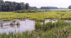
Similarly, the sedimentary deposits left by successive glaciations tens of thousands of years ago have created a natural filtration system under our noses. Most of the residents living within the French Creek Watershed get their water from this underground aquifer. Wetlands, such as marshes, swamps, and fens are all found within the French Creek watershed. Conneaut Marsh is an example of such a wetland and works to control flooding, filter excess nutrients in the water and provide habitat to several aquatic species.
In 2000 and 2001 French Creek was the focus of river conservation plan development project initiated by the Western Pa Conservancy and the French Creek Project. The plan was developed to assist watershed steakholders, landowners, and elected officials in making decisions concerning the watershed. To visit the plan please Click Here.
Soils in the French Creek Watershed
The soils in the study area can be divided roughly into two broad groups: the Venango-Frenchtown-Cambridge Association, formed of materials weathered from glacial till and found on the uplands, and the Holly-Red Hook-Chenango Association, characterized by deep, very poorly drained to somewhat excessively drained soils, nearly level soils that formed in materials weathered from stream deposits and glacial outwash. The highly erodible nature of these soils make the area particularly vulnerable to soil loss problems. (Yaworski, M., et al 1979). Click Here for more information on soils in Crawford County
Agricultural Best Management Practice programs in the French Creek Watershed
Curently through the efforts of the Crawford County Conservation District, French Creek Project, DCNR Bureau of Forestry, and Natural Resources Conservation Service several cost share assistance programs have been developed to assist farmers in the region improve their farming operations and protect water quality.
Active Watershed Groups in the French Creek Watershed
Friends of Tamarack Lake
Website: http://friendsoftamaracklake.com/index.html
Facebook page: https://www.facebook.com/pages/Friends-of-Tamarack-Lake/355815427821045
Conneaut Lake Aquatic Management Association
PO Box 49
Conneaut Lake, Pa 16314
Ph: 814/ 382-2967
Facebook page: https://www.facebook.com/pages/Conneaut-Lake-Aquatic-Management-Association/173164932736563
French Creek Valley Conservancy
PO Box 434
Meadville, Pa 16335
Ph: 814/337-4321
Website: http://frenchcreekconservancy.org/
PA Environmental Digest article on French Creek
Erie Times News five part series on French Creek
Oil Creek Watershed
Oil Creek Watershed is located in the eastern part of Crawford County. Oil Creek drains an area of approximately 340 square miles, mainly within Venango, Crawford and Warren Counties. In Crawford County it comprises 167 square miles, or 107,369 acres. The area boasts some of the most dramatic topography in the county. The hillsides are forested and the streams clean and clear. The majority of the Crawford County’s Exceptional Value and High Quality streams are found in this watershed, and it is a fly fisherman’s paradise.
Soils in the Oil Creek Watershed
This area includes soil types that are some of the county’s best. The Wooster Cambridge Complex consists of land that is well and moderately well-drained, and the Hanover-Alvira Association consists of both well-drained (Hanover) and poorly drained (Alvira) soils. Both of these soil types have been formed from glacial till and loess. (Yaworski, M., et al 1979). Click Here for more information on Crawford County Soils.
Oil Creek and the Ice Age
Like the other watersheds in Crawford County the Oil Creek Watershed was greatly affected by the successive glacial events of the last few Ice Ages. Unlike any other watersheds in Crawford County, Oil Creek was only partially covered by the Wisconsinan glaciation 17,000-22,000 years ago. This last great glacial event terminated in Crawford County where the existing Troy, Steuben, and Rome townships exist. If you look at a copy of a Crawford County USGS topographic map you can see evidence of this ending point, or terminal Moraine of the Wisconsinan glaciation. The extreme southern portion of the Oil Creek Watershed in Crawford County was last covered by the Late Illinoian glacial epoch 132,000-198,000 years ago. This had a profound effect on the Oil Creek Watershed. Before the Ice Age present day Oil Creek was actually part of two separate systems. The water north of Titusville flowed into Muddy Creek and northward on to present day Lake Erie. The water south of the Titusville area would have flowed south to the Allegheny River. There was a drainage divide just north of the city of Titusville separating the two systems. The advance of the last ice age would have presented the northward flowing river system with a 1-mile thick obstacle. The glacier created a dam effect, which backed up the northward flowing streams until they overtopped their watershed boundaries, and started to flow southward to the Ohio River Basin through broadened floodplains and over deepened channels. After the glaciers retreated a new drainage divide was established in the Tryonville area of Crawford County. The Eastern portion of Muddy Creek was cut off and became the headwaters of Oil Creek at present day Canadohta Lake. For more information on the glacial geomorphology in Pennsylvania Click Here.
Canadohta Lake
A glacial lake, formed 17,000-22,000 years ago during the Wisconsinan glaciation, Canadohta is the second largest natural lake (168 acres) in Crawford County, and one of the few kettle bottom spring fed lakes in Northwestern Pennsylvania.
Canadohta is a four-seasons sportsman’s paradise- well stocked with an array of fish, from pan fish, sunfish, bluegill, perch, crappie, and bullheads, to record-keeping muskellunge, northern pike, walleye, small and large mouth bass. There are also many local streams for trout fishermen.
Canadohta Lake History
The lake was originally named Lake Washington because it was thought that George Washington was a friend of Colonel Crawford, who named the county during the Revolutionary War.
In the latter part of the eighteenth century, the Cornplanter Tribe of the Six Nations camped at the lake for the spring and summer planting corn, making syrup from the sap of maple trees, and taking oil from nearby waters by use of blankets.
In 1860, the name Lake Washington was changed to Oil Creek Lake because it is the origin of the Oil Creek Watershed.
The Titusville and Union City Railroad operated here from 1860-1984. During this early period, an amusement park was built at Oil Creek on the southwest side of the lake where large groups would come to enjoy a shooting gallery, dance hall, bowling alley, billiard hall, and steamboat rides.
In 1894, the Canadohta Lake Club renamed the lake Canadohta Lake after Chief Canadaughta, a chief of the powerful Cornplanter Tribe.
Through the action of a local landowner and farmer, Ben Ruggles, in 1905 Canadohta Lake was rendered a public trust by the state of Pennsylvania.
Titusville Wellhead Protection Committee
107 North Franklin St.
Titusville, Pa 16354
Ph: 814/827-5300
E-mail: manager@cityoftitusvillepa.gov
Bloomfield (Canadohta) Lake Authority
Russ Campbell
E-Mail: ka3wnl@verizon.net
Website: http://www.canadohtalake.org/
Lake Erie Watershed: Conneaut Creek and Ashtabula Creek
About the Watersheds
Crawford County contains the very headwaters of the Conneaut and Ashtabula Creek Watersheds. Conneaut Creek flows northward into Lake Erie near Conneaut Ohio. Ashtabula Creek flows into the Ashtabula River, then ultimately into Lake Erie.
The Conneaut Creek watershed takes in 61,450 acres, or 96 square miles. Some streams included in this watershed are the Main Branch, West Branch, Middle Branch, and East Branch of Conneaut Creek, and Stone Run. The watershed is located in Beaver, Spring, Conneaut, Summerhill and Summit Townships in Crawford County.
The Lake Erie Watersheds and the Ice Age
The Conneaut Creek and Ashtabula Creek Watersheds are the only Crawford County systems that still drains northward into Great Lakes. Originally, all Crawford County streams drained in this direction, but with the coming of the Illinoian and Wisconsinan glaciers the drainage of the streams reversed from the north to the south, where they now enter the Ohio River Basin system. For more information on the glacial geomorphology in Pennsylvania Click Here.
Topography and Soils
The watershed is characterized by broad plains, rolling hills, and wetlands. The topography is the lowest in Crawford County, ranging from 1200 to 1100 feet above sea level. The bedrock in this area belongs to the “Conneaut Group”, a formation that consists of alternating gray, brown, greenish and purplish shales and siltstones, and the “Cattaraugus formation”, which includes red, gray, and brown shale and sandstone. The soil types in this area generally fall into the Sheffield-Platea association: Deep, poorly drained and somewhat poorly drained, nearly level and gently sloping soils that formed in materials weathered from glacial till. The representative profile of the surface layer is a dark-gray silt loam approximately 10 inches thick. The subsoil extends to a depth of 54 inches. A high water table is at or near the surface much of the year. These soils are difficult to develop because of a high water table and very slow permeability. (Yaworski, M., et al 1979).
Farming in the Lake Erie Watershed
Dairy farming is a major type of farming in this watershed. Agricultural activity accounts for slightly less than one third of the land use. Two-thirds of the land in agricultural use is in pasture or hay. Forested land accounts for approximately one-third of the remaining land use, and the rest is idle. The combination of wetlands, fields, and woodlands provide ample habitat for wildlife, making activities such as hunting and trapping lucrative. Additionally, drillers have found and tapped into many deposits of natural gas.
Active Watershed Associations in the Lake Erie Watershed
PA Lake Erie Watershed Association
Contact: Sarah Galloway
Ph: 814/ 870-1255
E-mail: sgalloway@erie.pa.us
Website: http://www.eriewatershed.org/