Soil Survey
What is a soil survey map?
 Map sheets are made from aerial photographs of the county. On each sheet of a detailed map, soil areas are outlined and are identified by symbols. Soil scientists made this survey to learn what kind of soils are in Crawford County, where they are located and how they can be used. This is a publication of the National Cooperative Soil Survey, a joint effort of USDA’s Natural Resources Conservation Service, the Pennsylvania State University of Agriculture and the PA Department of Environmental Protection, State Conservation Commission.
Where do you find the meaning of each symbol?
A “Soil Legend” sheet, “Brief Soil Descriptions,” and informational sheets about hydric or wet soils is given each person asking for a soil survey sheet of a specific area within the county. If you qualify for a Crawford County Soil Survey Book, there is a “Guide to Mapping Units” which can also be used to find information. This guide lists all the soils in the county, gives the capability classification of each and shows the page where each soil is described.
Who would use a soil survey map sheet or book?
- Farmers and those who work with farmers can learn about use and management of the soils from soil descriptions.
- Foresters and others can refer to the section “Use of the Soils for Woodland,” where the soils of the county are rated according to their suitability for trees.
- Wildlife managers and others can find information about soils and wildlife in the section “Use of the Soils for Wildlife.”
- Community planners and others can read about soil properties that affect the choice of sites for dwellings, industrial buildings and recreation areas in the sections “Use of the Soils for Town and Country Planning” and “Use of the Soils for Recreation Development.”
- Engineers and builders can find, under “Engineering Use of the Soils,” tables that contain test data, estimates of soil properties, and information about soil features that affect engineering practices.
- Scientists and others can read about how the soils formed and how they are classified in the section “Formation, Morphology, and Classification of the Soils.”
- Newcomers in Crawford County may be especially interested in the section “General Soil Map,” where broad patterns of soils are described. They may also be interested in the information about the county given in the section “Environmental Factors Affecting Soil Use.”
Crawford County Soil Survey
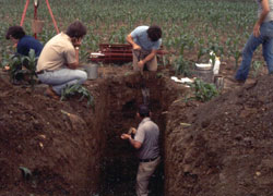
The Soil Conservation Service (now the Natural Resources Conservation Service) published the Crawford County Soil Survey in 1979. Soil survey reports were completed for most all counties, not only in Pennsylvania, but in the United States, during the 60-70’s. Over several years soil scientists observed the soils by digging test pits and performing visual inspection across the state. They classified and named the soils according to nationwide uniform procedures. This information was then compiled into survey books for each county.
Soil survey reports are still available through the Natural Resources Conservation Service, now located at 14699 North Main Street Extension in Meadville, PA. The reports are free of charge if picked up at the office, however there is a $5 shipping fee if they are mailed.
The book gives a general description of Crawford County followed by an explanation of how the survey was made. Included is a general soils map of the county and descriptions of each of the soil associations. The survey further describes each soil series and lists several soil features of those series. The remainder of the book is a compilation of maps that have the soil types overlain on top of aerial photographs.
Crawford County Soils
Crawford County lies entirely in the glaciated part of the Allegheny Plateau, with greatly varying topography from east to west. The eastern portion of the county has irregular terrain with deeper valleys and steeper slopes and like most of the country it drains south into the Allegheny River system. The northwestern area of the county is quite flat and drains into Lake Erie. Due to this flat landscape and slow permeability of the sub soil a large portion of the northwest is very poorly drained. Nearly three fourths of the county consists of soils that are very poorly to somewhat poorly drained. 65% of the land area needs artificial drainage before it could be effectively used as farmland. Only about 10% is best suited for farming without any special management and about 20% is either too steep, stony or swampy for intensive use. 5% of the soils are droughty.
Soil Drainage
Natural soil drainage refers to the conditions of frequency and duration of periods of saturation or partial saturation that existed during the development of the soil opposed to the altered drainage that is the result of artificial drainage or irrigation. Natural drainage is categorized into 7 classes.
- Excessively drained
- Somewhat excessively drained
- Well drained
- Moderately well drained
- Somewhat poorly drained
- Poorly drained
- Very poorly drained
Soil Associations
There are 5 soil associations in the county:
- Venango-Frenchtown-Cambridge
- Holly-Red Hook- Chenango
- Valois-Cambridge
- Sheffield-Platea
- Hanover-Alvira.
The soil types of Crawford County include:
| Soil Type | Symbol | Hydrologic Soil Group | Capability Class | ||
| Alden | Ad | D | IV | w | 2 |
| Alvira | AvA | C | III | w | 3 |
| Alvira | AvB | C | III | w | 2 |
| Braceville | BrA | C | II | w | 2 |
| Braceville | BrB | C | II | e | 3 |
| Cambridge | CaA | C | II | w | 2 |
| Cambridge | CaB | C | II | e | 2 |
| Cambridge | CaC | C | III | e | 1 |
| Cambridge | CaD | C | IV | e | 1 |
| Cambridge | CbB | C | VI | s | 1 |
| Cambridge | CbD | C | VI | s | 2 |
| Cambridge | CcB | C | III | w | 1 |
| Candice | Cd | D | IV | w | 2 |
| Caneadea | CeA | D | III | w | 2 |
| Caneadea | CeB | D | III | w | 1 |
| Carlisle muck | CM | D | VII | w | 1 |
| Chenango | CoA | A | II | s | 1 |
| Chenango | CoB | A | II | s | 3 |
| Chenango | CoC | A | III | e | 3 |
| Frenchtown | FhA | D | III | 3 | |
| Frenchtown | FhB | D | III | w | 1 |
| Frenchtown | FvB | D | VII | w | 1 |
| Halsey | Ha | D | IV | s | 2 |
| Hanover | HnA | C | II | w | 2 |
| Hanover | HnB | C | II | w | 2 |
| Hanover | HnC | C | III | e | 2 |
| Hanover | HoB | C | VI | e | 1 |
| Hanover | HoD | C | VI | s | 1 |
| Haven | HvA | B | I | s | 2 |
| Haven | HvB | B | II | e | 1 |
| Holly | Hy | D | III | w | 1 |
| Hz | VI | w | 1 | ||
| Philo | Ph | B | II | w | 1 |
| Platea | PkB | C/D | III | w | 2 |
| Pope | Po | B | I | 1 | |
| Redhook | Rh | C | III | w | 2 |
| Scio | ScA | B | II | w | 2 |
| Scio | ScB | B | II | e | 2 |
| Sheffield | Sh | D | III | w | 3 |
| Sheffield | SmA | D | IV | w | 1 |
| Shelmadine | SmB | D | IV | w | 1 |
| Valois | VaB | D | II | e | 1 |
| Valois | VaC | D | III | e | 1 |
| Valois | VaD | D | IV | e | 1 |
| Valois | VLF | D | VI | e | 1 |
| Valois | VmB | D | II | e | 2 |
| Valois | VmC | D | III | e | 2 |
| Venango | VnA | C | III | w | 2 |
| Venango | VnB | C | III | w | 2 |
| Venango | VnC | C | III | e | 4 |
| Venango | VoB | C | VI | s | 1 |
| Venango | VoC | C | VI | s | 1 |
| Wyoming | WyA | A | III | s | 1 |
| Wyoming | WyB | A | III | s | 1 |
| Wyoming | WyC | A | IV | e | 2 |
| Wyoming | WyD | A | VI | e | 1 |
Lists of Mapping Units that Qualify as Prime Farmland
| BrA | Braceville | gravelly loam, 0-3% slope |
| BrB | Braceville | gravelly loam, 3-8% slope |
| CaA | Cambridge | silt loam, 0-3% slope |
| CoA | Chenango | gravelly loam, 0-3% slope |
| CoB | Chenango | gravelly loam, 3-8% slope |
| HnA | Hanover | silt loam, 0-3% slope |
| HnB | Hanover | silt loam, 3-8% slope |
| HvA | Haven | silt loam, 0-3% slope |
| Ph | Philo | silt loam |
| Po | Pope | loam |
| ScA | Scio | silt loam, 0-3% slope |
| VaB | Valois | gravelly silt loam, 3-8% slope |
| VmB | Valois-Cambridge | complex, 3-8% slope |
Hydric Soils of Crawford County
| AD | Alden silt loam |
| CD | Canadice silt loam |
| CM | Carlisle Muck |
| FhA | Frenchtown silt loam, 0-3% slope |
| FhB | Frenchtown silt loam, 3-8% slope |
| FvB | Frenchtown very stony silt loam, 0-8% slope |
| Ha | Halsey silt loam |
| Hy | Holly silt loam |
| Hz | Holly silty clay loam |
| Sh | Sheffield silt loam |
| SmA | Shelmadine silt loam, 0-3% slope |
| SmB | Shelmadine silt loam, 3-8% slope |
This list of hydric soils contain soils that are sufficiently wet under undrained conditions to support the growth and regeneration of hydrophytic vegetation.
Textural Classes
Soil is made up of sand, silt and clay particles. The relative proportions of these particles in a mass of soil is the soil texture. The basic textural classes in order of increasing proportion of fine particles are:
- Sand
- Loamy Sand
- Sandy Loam
- Loam
- Silt Loam
- Silt
- Sandy Clay Loam
- Clay Loam
- Silty Clay Loam
- Sandy Clay
- Silty Clay
- Clay
| Range of Particle Sizes | |
| Silt | 0.002 – 0.05 mm |
| Sand | 0.05 – 2.0 mm |
| Clay less than | 0.002 mm |
Soil Descriptions for Crawford County
*Hydric soils are indicated by being underlined
Alden Soils | Alvira Soils | Braceville Soils | Cambridge Soils | Canadice Soils | Canadea Soils
Carlisle Soils | Chenango Soils | Frenchtown Soils | Halsey Soils | Hanover Soils | Haven Soils
Holly Soils | Philo Soils | Platea Soils | Pope Soils | Red Hook Soils | Scio Soils | Sheffield Soils
Shelmadine Soils | Valois Soils | Venango Soils | Wyoming Soils
Alden Soils
The Alden are deep, very poorly drained soils formed in materials weathered from glacial till and local alluvium. They have a moderately slowly permeable subsoil and a water table at the surface during most of the year. Most use problems are related to high water table and moderately slow permeability.
| Ad | Alden silt loam |
Alvira Soils
The Alvira soils are deep, somewhat poorly drained soils formed in materials weathered from glacial till. They have a slowly permeable subsoil and a seasonal high water table at 0.5 to 1.5 feet below the surface during wet periods. Most use problems are related to seasonal high water table and slow permeability.
| AvA | Alvira silt loam, 0 to 3 percent slopes |
| AvB | Alvira silt loam, 3 to 8 percent slopes |
Braceville Soils
The Braceville soils are deep, moderately well drained formed in materials weathered from water-sorted sand, silt, and gravel. They have a moderately slowly permeable subsoil and a seasonably high water table at 1.5 to 3.0 feet below the surface during wet periods. Most use problems are related to seasonal high water table and moderately slow permeability.
| BrA | Braceville gravelly loam, 0 to 3 percent slopes |
| BrB | Braceville gravelly loam, 3 to 8 percent slopes |
Cambridge Soils
The Cambridge are deep, moderately well drained soils formed in materials weathered from glacial till. They have a very slowly permeable subsoil and a seasonably high water table at 1.5 to 3.0 feet below the surface during wet periods. Most use problems are related to seasonal high water table and very slow permeability.
| CaA | Cambridge silt loam, 0 to 3 percent slopes |
| CaB | Cambridge silt loam, 3 to 8 percent slopes |
| CaC | Cambridge silt loam, 8 to 15 percent slopes |
| CaD | Cambridge silt loam, 15 to 25 percent slopes |
| CbB | Cambridge very stony silt loam, 0 to 8 percent slopes |
| CbD | Cambridge very stony silt loam, 8 to 25 percent slopes |
| CcB | Cambridge-Venango silt loams, 3 to 8 percent slopes |
Canadice Soils
The Canadice are deep, poorly drained soils formed in materials weathered from glacial sediments. They have a very slowly permeable subsoil and a water table at or near the surface during much of the year. Most use problems are related to high water table and very slow permeability.
| Cd | Canadice silt loam |
Canadea Soils
The Canadea are deep, somewhat poorly drained soils formed in materials weathered from glacial lake deposits. They have a very slowly permeable subsoil and a seasonal high water table at 0.5 to 1.5 feet below the surface during wet periods. Most use problems are related to high water table and very slow permeability.
| CeA | Canadea silt loam, 0 to 3 percent slopes |
| CeB | Canadea silt loam, 3 to 8 percent slopes |
Carlisle Soils
The Carlisle are deep, very poorly drained soils formed in materials weathered from woody and herbaceous organic deposits. They have a moderately rapidly permeable subsoil and a water table at the surface during all of the year. Most use problems are related to high water table and flooding.
| CM | Carlisle Muck |
Chenango Soils
The Chenango are deep, well to somewhat excessively drained soils formed from materials weathered from glacial outwash. They have a moderate to moderately rapidly permeable subsoil . Most use problems are related to droughtiness and moderately rapid permeability.
| CoA | Chenango gravelly silt loam, 0 to 3 percent slopes |
| CoB | Chenango gravelly silt loam, 3 to 8 percent slopes |
| CoC | Chenango gravelly silt loam, 8 to 15 percent slopes |
Frenchtown Soils
The Frenchtown are deep, poorly drained soils formed in materials weathered from glacial till. They have a slowly permeable subsoil and a high water table at or near the surface during much of the year. Most use problems are related to high water table and slow permeability.
| FhA | Frenchtown silt loam, 0 to 3 percent slopes |
| FhB | Frenchtown silt loam, 3 to 8 percent slopes |
| FvB | Frenchtown very stony silt loam, 0 to 8 percent slopes |
Halsey Soils
The Halsey are deep, very poorly drained soils formed in materials weathered from glacial outwash and local alluvium. They have a moderately slowly permeable subsoil and a high water table at the surface during most of the year. Most use problems are related to high water table and slow permeability.
| Ha | Halsey silt loam, 0 to 3 percent slopes |
Hanover Soils
The Hanover are deep, moderately well drained soils formed in materials weathered from glacial till. They have a moderately slowly permeable subsoil and a seasonal high water table at 0.5 to 1.5 feet below the surface during wet periods. Most use problems are related to seasonal high water table and moderately slow permeability.
| HnA | Hanover silt loam, 0 to 3 percent slopes |
| HnB | Hanover silt loam, 3 to 8 percent slopes |
| HnC | Hanover silt loam, 8 to 15 percent slopes |
| HoB | Hanover very stony silt loam, 0 to 8 percent slopes |
| HoD | Hanover very stony silt loam, 8 to 25 percent slopes |
Haven Soils
The Haven are deep, well drained soils formed in materials weathered from glacial stream deposits. They have a moderately permeable subsoil. Most use problems are related to slope or hazard of groundwater pollution.
| HvA | Haven silt loam |
| HvB | Haven silt loam |
Holly Soils
The Holly are deep, poorly to very poorly drained soils formed in materials weathered from stream deposits. They have a moderately to moderately slow permeable subsoil and a high water table at or near the surface during much of the year. Most use problems are related to flood hazard, high water table, and moderately slow permeability.
| Hy | Holly silt loam |
| Hz | Holly silty clay loam |
Philo Soils
The Philo are deep, moderately well drained soils formed in materials weathered from stream deposits. They have a moderate to moderately slowly permeable subsoil and a seasonal high water table at 1.5 to 3.0 feet below the surface during wet periods. Most use problems are related to flooding hazard, moderately slow permeability, and seasonal high water table.
| Ph | Philo silt loam, 0 to 3 percent slopes |
Platea Soils
The Platea are deep, somewhat poorly drained soils formed in materials weathered from glacial till. They have a very slowly permeable subsoil and a seasonal high water table at 0.5 to 1.5 feet below the surface during wet periods. Most use problems are related to seasonal high water table and very slow permeability.
| PkB | Platea silt loam, 3 to 8 percent slopes |
Pope Soils
The Pope are deep, well drained soils formed in materials weathered from stream deposits. They have a moderately permeable subsoil. Most use problems are related to flooding hazard.
| Po | Pope loam, 0 to 3 percent slopes |
Red Hook Soils
The Red Hook are deep, somewhat poorly drained soils formed in materials weathered from glacial outwash. They have a slowly permeable fragipan and a seasonal high water table at 0.5 to 3.0 feet below the surface during wet periods. Most use problems are related to seasonal high water table and slow permeability.
| Rh | Red Hook loam, 0 to 5 percent slopes |
Scio Soils
The Scio are deep, moderately well drained soils formed in materials weathered from glacial stream deposits. They have a moderately permeable subsoil and a seasonal high water table at 1.5 to 3.0 feet below the surface during wet periods. Most use problems are related to seasonal high water table.
| ScA | Scio silt loam, 0 to 3 percent slopes |
| ScB | Scio silt loam, 3 to 8 percent slopes |
Sheffield Soils
The Sheffield are deep, poorly drained soils formed in materials weathered from glacial till. They have a very slowly permeable subsoil and a high water table at or near the surface during much of the year. Most use problems are related to high water table and very slow permeability.
| Sh | Sheffield silt loam, 0 to 3 percent slopes |
Shelmadine Soils
The Shelmadine are deep, poorly drained soils formed in materials weathered from glacial till. They have a slowly permeable subsoil and a high water table at or near the surface during much of the year. Most use problems are related to high water table and slow permeability.
| SmA | Shelmadine silt loam, 0 to 3 percent slopes |
| SmB | Shelmadine silt loam, 3 to 8 percent slopes |
Valois Soils
The Valois are deep, well drained soils formed in materials weathered from glacial till. They have a moderately permeable subsoil. Most use problems are related to coarse fragments and slope.
| VaB | Valois gravelly silt loam, 3 to 8 percent slopes |
| VaC | Valois gravelly silt loam, 8 to 15 percent slopes |
| VaD | Valois gravelly silt loam, 15 to 25 percent slopes |
| VLF | Valois soils, 25 to 60 percent slopes |
| VmB | Valois-Cambridge complex, 3 to 8 percent slopes |
| VmC | Valois-Cambridge complex, 8 to 15 percent slopes |
Venango Soils
The Venango are deep, somewhat poorly drained soils formed in materials weathered from glacial till. They have a very slowly permeable fragipan and seasonal high water table at 0.5 to 1.5 feet below the surface during wet periods. Most use problems are related to seasonal high water table and very slow permeability.
| VnA | Venango silt loam, 0 to 3 percent slopes |
| VnB | Venango silt loam, 3 to 8 percent slopes |
| VnC | Venango silt loam, 8 to 15 percent slopes |
| VoB | Venango very stony silt loam, 0 to 8 percent slopes |
| VoC | Venango very stony silt loam, 8 to 15 percent slopes |
Wyoming Soils
The Wyoming are deep, somewhat excessively drained soils formed in materials weathered from water sorted sand, silt, and gravel. They have a rapidly permeable subsoil. Most use problems are related to coarse fragments, rapid permeability, and low available water capacity.
| WyA | Wyoming gravelly sandy loam, 0 to 3 percent slopes |
| WyB | Wyoming gravelly sandy loam, 3 to 8 percent slopes |
| WyC | Wyoming gravelly sandy loam, 8 to 15 percent slopes |
| WyD | Wyoming gravelly sandy loam, 15 to 25 percent slopes |
Soil Survey Information on the Web
As county soil information is digitized, it is posted on the following websites: